


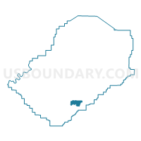
Muscoda Community Center, Jefferson County, Alabama
About
Outline

Summary
| Unique Area Identifier | 522039 |
| Name | Muscoda Community Center |
| County | Jefferson County |
| State | Alabama |
| Area (square miles) | 5.84 |
| Land Area (square miles) | 5.75 |
| Water Area (square miles) | 0.08 |
| % of Land Area | 98.57 |
| % of Water Area | 1.43 |
| Latitude of the Internal Point | 33.37447000 |
| Longtitude of the Internal Point | -86.88414710 |
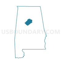
Maps

Graphs
Select a template below for downloading or customizing gragh for Muscoda Community Center, Jefferson County, Alabama


Neighbors
Neighoring Voting District (by Name) Neighboring Voting District on the Map
- Canaan Baptist Church, Jefferson County, AL
- Hunter Street Baptist Church, Jefferson County, AL
- Muscoda Community Center, Jefferson County, AL
- Prince of Peace Catholic Church, Jefferson County, AL
- Ross Bridge Welcome Center Town Hall, Jefferson County, AL
Top 10 Neighboring County Subdivision (by Population) Neighboring County Subdivision on the Map
- Birmingham CCD, Jefferson County, AL (455,278)
- Hoover CCD, Jefferson County, AL (45,938)
- Greenwood CCD, Jefferson County, AL (22,289)
Top 10 Neighboring Place (by Population) Neighboring Place on the Map
Top 10 Neighboring Unified School District (by Population) Neighboring Unified School District on the Map
- Jefferson County School District, AL (230,679)
- Birmingham City School District, AL (212,237)
- Hoover City School District, AL (81,093)
- Bessemer City School District, AL (27,456)
Top 10 Neighboring State Legislative District Lower Chamber (by Population) Neighboring State Legislative District Lower Chamber on the Map
- State House District 46, AL (50,398)
- State House District 52, AL (43,159)
- State House District 56, AL (41,064)
Top 10 Neighboring State Legislative District Upper Chamber (by Population) Neighboring State Legislative District Upper Chamber on the Map
- State Senate District 14, AL (168,669)
- State Senate District 16, AL (149,527)
- State Senate District 18, AL (112,472)
- State Senate District 19, AL (109,165)
Top 10 Neighboring 111th Congressional District (by Population) Neighboring 111th Congressional District on the Map
Top 10 Neighboring Census Tract (by Population) Neighboring Census Tract on the Map
- Census Tract 142.04, Jefferson County, AL (9,787)
- Census Tract 144.13, Jefferson County, AL (8,852)
- Census Tract 143.02, Jefferson County, AL (5,666)
- Census Tract 143.01, Jefferson County, AL (2,802)